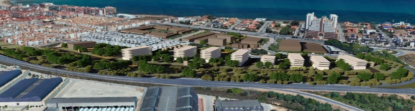
The developer behind the Villa Amalia development in Torrevieja has revised the proposal to complete the sector situated to the south of the urban centre and next to the N-332 road. A draft modification from 2024 allowed buildings of up to eight and ten storeys, whereas the current project reduces the maximum heights to six and seven storeys. The total number of housing blocks has also been cut from 16 to eight, although this figure is not finalised. The plan modification, which is currently open to public consultation, concentrates 455 homes and 27,283 square metres of buildable space in the central area. It maintains the maximum of 925 homes planned for the entire sector and frees the frontage closest to the main road from residential use. The proposal does not increase total residential buildability. The administrative process includes a public information period of 45 working days before moving towards final approval.

A large part of the modification stems from the N-332 itself. The Partial Plan approved by the Department of Territory in November 2005 organised Villa Amalia without incorporating the future project to dual the Torrevieja bypass. This was permitted by Torrevieja Town Council, which was ironically already calling on central government to dual the road at that time. The council later approved the development project in 2008, but the Highways Department issued a negative report in 2010 and subsequently requested documentation regarding public domain, building limit lines, drainage and noise.
The specific project to dual the N-332 bypass was formulated by Highways in 2020. The layout occupies part of the green protection strip planned next to the road and brings the infrastructure closer to the residential plots on the western edge. Consequently, documentation considers it necessary to remove the planned housing from that zone and replace it with open spaces, green areas and hydraulic infrastructure. Moving these buildings forces a redistribution of buildable space. The three plots that cease to be residential had 146 homes and 8,804 buildable square metres assigned to them. That capacity moves to two large vacant residential blocks in the interior. This avoids any financial compensation claim by the developer against the council or administration carrying out the dual carriageway work, which the company has taken as an opportunity to build upwards.
One plot now moves from 175 to 258 homes and from 10,471 to 15,461 buildable square metres. The other increases from 134 to 197 homes and from 8,008 to 11,822 square metres. Between both, they maintain the same 455 homes and 27,283 square metres previously distributed across five plots.
Maintaining the two storeys envisioned in the 2005 plan for all that capacity would force buildings to occupy approximately 57% of both blocks according to planners’ calculations. The project discards this option because it would create an overly dense frontage, reduce interior open spaces and hinder visual permeability. The solution is to occupy less ground and build vertically.
The 2005 Partial Plan set a maximum of ground floor plus one height for western residential plots. In other areas, it allowed up to ground floor plus three storeys for specific building types. The 2024 draft raised maximums to eight and ten storeys. The current version reduces that volume once more. One block will have a maximum of seven storeys in total (ground floor plus six) and 24.5 metres in height, while the other remains at six (ground floor plus five) and 21 metres. The reduction compared to the previous draft is between 25% and 30%.
Plans foresee erecting eight blocks, four in each section. However, documentation warns that these represent a possible solution and do not set a mandatory final number of buildings.
The height reduction was incorporated following comments from the Coastal Department. The General Sub-Directorate of Maritime-Terrestrial Public Domain reminded developers that Villa Amalia lies within the influence zone regulated by the Coastal Law and required new plans to avoid architectural screens and accumulated building volume. Building layout and height must harmonise with the surrounding environment without restricting visual fields or altering coastal views.
The Coastal Department did not explicitly order a reduction from ten to seven storeys but required justification for volume and height integration. Following that report, the project limits buildable areas, introduces open spaces between blocks and strengthens its landscape study. This analysis justifies reducing heights from eight and ten storeys to six and seven, taking into account the depressed topography of the sector.
The developer, Grupo Insara, took into account this report. The Sastre and Sastre design firm, which prepared the documentation, used the height reached by the main structure of the desalination plant as a reference for visual harmony, whilst noting that taller structures exist closer to the coast in La Veleta.
Highways has imposed further conditions on Villa Amalia. Future construction plans must define noise protection measures from the N-332 using acoustic barriers or earth mounds. Plans must also specify the location, dimensions, depth, waterproofing, evacuation and emptying of the storm tank. The infrastructure, existing pumping station and N-332 transversal drainage must prove capable of managing water reaching the low point of Calle Ramón Rubial to avoid flooding in the north of the sector and road impact.
The modification includes an adjustment in the commercial area. A plot measuring 3,347 square metres with 1,666 buildable square metres was listed in 2005 as commercial-catering despite other regulations assigning hotel uses. Planners considered this a typographical error and reclassified it as commercial-hotel. It will accommodate hotel complexes, hotels, aparthotels and tourist apartments with a maximum height of two storeys and seven metres.
Other Articles
Orihuela City Council finalises €23.1 million sale of coastal land
Five face trial over alleged 131,000€ fake villa sale fraud