

Torrevieja has presented the official map of its new urban transport network, which will begin implementation during this summer. The map will allow users to check routes, stops and connections between the main residential areas and the public facilities of the municipality.

The City Council and the concessionaire company Avanza have designed a scheme that differentiates each route by means of colours. The map also shows individual inbound and outbound journeys to facilitate the planning of trips.
Avenida Doctor Gregorio Marañón will function as one of the main connection points. From this axis, several services will depart towards hospitals, health centres, sports facilities, commercial areas, the bus station, the beaches and urbanisations.
The municipal information presents the service as a network made up of eight lines. However, the list of routes distributed enumerates a circular line and another eight lines numbered from 1 to 8.
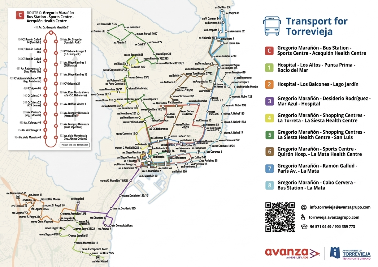
Routes of the new bus network in Torrevieja
Line C will have a circular route through the town centre. It will connect Avenida Doctor Gregorio Marañón with the bus station, the Municipal Sports Centre and the Acequión Health Centre. In addition, it will be the service with the highest frequency for internal travel.
Line 1 will connect Torrevieja University Hospital with Los Altos, Punta Prima and Rocío del Mar.
Line 2 will link the hospital with Los Balcones and Lago Jardín
Line 3 will join Avenida Doctor Gregorio Marañón with Desiderio Rodríguez, Mar Azul and the hospital centre.
Line 4 will connect the town centre with the commercial areas, La Torreta and the La Siesta Health Centre.
Line 5 will extend this route to San Luis and will also pass through the shopping centres and La Siesta.
For its part, line 6 will connect the centre with the Municipal Sports Centre, Quirón Hospital, the International Auditorium and the La Mata Health Centre. This service will also have special routes to the street market and to the Auditorium during the holding of events.
Line 7 will link Avenida Doctor Gregorio Marañón with Calle Ramón Gallud, Avenida de París and La Mata.
Line 8 will connect the centre of Torrevieja with Cabo Cervera, the bus station and La Mata, reinforcing public transport on the northern coast.
Consultation via QR code
The new map incorporates the location of the stops and their corresponding codes. It also includes the complete list of inbound and outbound routes so that users can identify the available connections with greater ease.
The information can be consulted in both printed and digital formats. A QR code will allow access to updated service data, whilst the map will include user service telephone numbers and the urban transport website.
The new cartography forms part of the implementation of the Torrevieja urban transport contract. The municipal objective is to adapt the service to population growth and improve travel between neighbourhoods, urbanisations and the main points of interest in the city.
Other Articles
Minor earthquake recorded in Los Montesinos this morning